History and Maps
Stawley is a village and civil parish in Somerset, England, situated 10 miles (16.1 km) west of Taunton. The parish had 138 dwellings and a population of 279 at the census of 2011. The parish includes the hamlets of Appley, Greenham, Kittisford and Tracebridge. The Domesday Book has listings for Stawley, Appley, Kittisford and Greenham. The total population at the time of the Book was 30 souls, 6 of whom were slaves. There were about 1,200 acres under the plough, 28 acres being used as pasture and 45 acres of woods.
The Parish isn’t a static place. Of interest is the idea that the population continually expands. Here in Stawley that is not the case. The population dropped by a third from about 360 to 240 between 1891 and 1960 since when it has risen to about 280.
In 1870-72, John Marius Wilson’s Imperial Gazetteer of England and Wales described Stawley like this:
STAWLEY, a parish in Wellington district, Somerset; 4½ miles W by N of Wellington r. station. Post town, Wellington, Somerset. Acres, 830. Real property, £1,182. Pop., 188. Houses, 40. The manor belongs to Messrs. Palmer and Sweet. The living is a rectory in the diocese of Bath and Wells. Value, £150. Patron, J. Hayne, Esq. The church is early English.
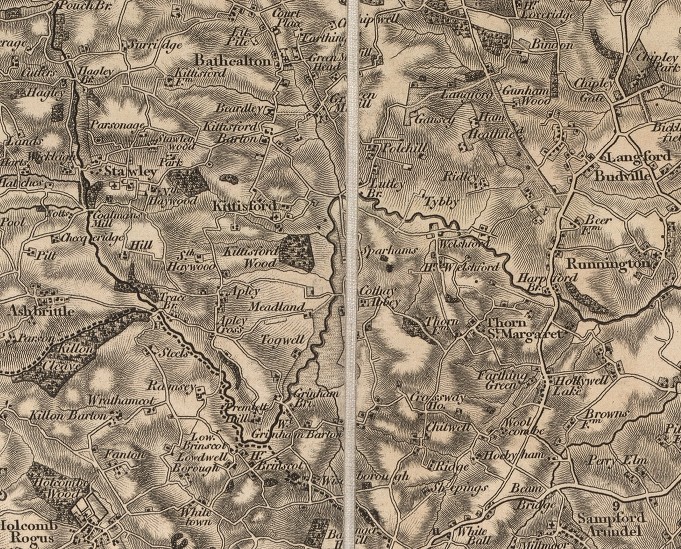
Old maps describe what has happened on the ground very well. The oldest that I have found is the 1st Edition of the Ordnance Survey produced in 1809. Our sheet is number 21 and as can be seen below. During the last 200 years spellings have changed and some places have disappeared. Greenham was Grinham and a place between Grinham Bridge and Meadland known as Togwell has disappeared as has a place called Crossways House that used to sit by the crossroads at the top of Fishers Hill.

While on the subject of maps there are many more available. A good place to start is on an external site held by the City of Bristol which compares what is on the map today with previous years. To take a look click here.